Mount Rinjani, located on the island of Lombok, Indonesia, is one of the most iconic and challenging volcanoes in Southeast Asia. With an elevation of 3,726 meters (12,224 feet) above sea level, it proudly stands as the second highest volcano in Indonesia after Mount Kerinci in Sumatra. Its towering presence and breathtaking landscapes attract thousands of hikers, trekkers, and adventure seekers every year.
In this comprehensive guide, we’ll dive deep into everything you need to know about Mount Rinjani’s elevation, how it affects trekking difficulty, the climate at different altitudes, and why it’s considered a sacred mountain by locals. Whether you’re planning to climb it yourself or simply curious about its significance, this article covers it all.
1. Overview of Mount Rinjani’s Elevation
Mount Rinjani rises to a staggering 3,726 meters (12,224 feet), making it the highest peak in Lombok and one of the tallest in Indonesia. At this elevation, the mountain dominates the island’s landscape and creates a unique ecosystem that ranges from tropical forests at lower levels to alpine conditions at higher altitudes.
This elevation not only contributes to its challenging trekking conditions but also provides some of the most rewarding views in the region. From the summit, trekkers can witness panoramic scenes of Mount Agung in Bali, the Gili Islands, and even parts of Sumbawa on clear days.
2. Mount Rinjani in Comparison with Other Indonesian Peaks
Indonesia is home to numerous volcanoes, many of which are active. Let’s compare Rinjani’s elevation with other famous peaks in the archipelago:
- Mount Kerinci (3,805 m / 12,484 ft) – The tallest volcano in Indonesia, located in Sumatra.
- Mount Rinjani (3,726 m / 12,224 ft) – Second highest, located in Lombok, West Nusa Tenggara.
- Mount Semeru (3,676 m / 12,060 ft) – The highest peak in Java and one of the most popular trekking destinations.
- Mount Agung (3,031 m / 9,944 ft) – Bali’s sacred mountain, visible from Rinjani’s summit.
This comparison shows that Rinjani’s elevation places it among the top three tallest volcanoes in Indonesia, making it a significant destination for mountaineers.
3. Trekking Routes and Elevation Gains
Climbing Mount Rinjani involves steep elevation gains, no matter which route you choose. The two most popular gateways are Sembalun and Senaru, each offering unique trekking experiences.
- Sembalun Route (1,150 m / 3,773 ft starting point)
- Known for its long but gradual climb.
- Provides wide-open views of rolling hills and savanna.
- Total elevation gain to the summit: 2,576 meters (8,451 feet).
- Senaru Route (600 m / 1,969 ft starting point)
- Starts at a lower elevation, making the climb steeper.
- Dense tropical forest dominates the trail.
- Total elevation gain to the summit: 3,126 meters (10,255 feet).
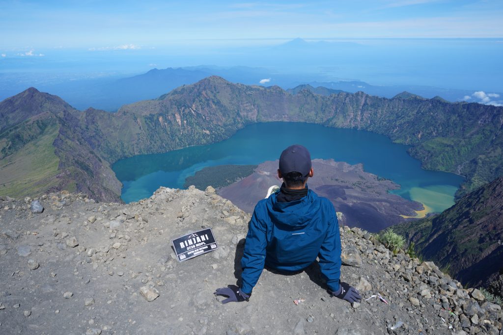
Both routes converge at Lake Segara Anak, a stunning crater lake located at 2,008 meters (6,588 feet). From there, trekkers can either descend or continue towards the summit.
4. How Elevation Affects the Trekking Difficulty
The high elevation of Mount Rinjani poses several challenges:
- Altitude sickness: Above 2,500 meters, trekkers may experience headaches, dizziness, or fatigue due to reduced oxygen levels.
- Steep terrain: The final summit push from the crater rim to 3,726 meters involves loose volcanic sand and gravel, making every step physically demanding.
- Cold temperatures: Despite being in tropical Indonesia, temperatures at the summit can drop below 5°C (41°F), especially before sunrise.
These factors make Rinjani a tough but rewarding trek, requiring good fitness levels and preparation.
5. Climate and Weather at Different Elevations
Mount Rinjani’s elevation creates varying climates as you ascend:
- Lowlands (0–1,000 m): Hot and humid tropical conditions with lush forests.
- Mid-range (1,000–2,000 m): Cooler temperatures, dense jungle, and increased rainfall.
- Crater lake level (2,000 m): Fresh mountain air with chilly nights.
- Summit zone (3,000+ m): Harsh, windy, and cold, with little vegetation.
The best time to climb Rinjani is during the dry season (April–October) when the skies are clear, and trails are safer.
6. Sacred Significance of Rinjani’s Elevation
For the Sasak people of Lombok and the Balinese Hindu community, Rinjani is more than just a mountain. Its towering elevation makes it a sacred site of pilgrimage. The crater lake, Segara Anak, is believed to be holy, and religious ceremonies are often held there.
The elevation symbolizes a connection between the earthly world and the divine, making Rinjani not only a natural wonder but also a spiritual landmark.
7. Unique Features at Different Elevations
Mount Rinjani is not just about its peak — the elevations along the way host fascinating natural wonders:
- Segara Anak Lake (2,008 m) – A turquoise crater lake formed after past eruptions.
- Gunung Barujari (2,376 m) – A smaller active volcano rising from the lake, often called the “child of Rinjani.”
- Hot Springs (near Segara Anak) – Natural hot springs believed to have healing powers.
- Savanna and Alpine Meadows – Found above 2,000 meters, providing breathtaking landscapes.
8. The Experience of Reaching the Summit
Mount Rinjani elevation-Reaching the summit at 3,726 meters is considered the highlight of any Rinjani trek. The final stretch begins around 2 a.m., ensuring trekkers arrive at sunrise. The view from the top is simply unforgettable:
- To the west: Mount Agung and Bali.
- To the east: Mount Tambora in Sumbawa.
- Below: The shimmering Segara Anak Lake.
The sense of achievement at this elevation makes all the struggle worthwhile.
9. Preparing for the Elevation Challenge
To conquer Mount Rinjani’s elevation safely, preparation is key:
- Train in advance with cardio, strength, and hiking practice.
- Acclimatize by spending time at mid-elevations before tackling the summit.
- Pack properly, including warm clothes, trekking poles, and headlamps.
- Hire local porters and guides for safety, navigation, and cultural insights.
Being well-prepared ensures you enjoy the climb rather than struggle through it.
10. Why Mount Rinjani’s Elevation Makes It World-Famous
Mount Rinjani’s elevation is not just a number; it’s the reason why it is:
- A bucket-list trek for adventure travelers.
- A photographer’s paradise with panoramic views.
- A sacred pilgrimage site for locals.
- An ecological treasure with diverse flora and fauna.
This combination of natural beauty, physical challenge, and cultural importance makes Rinjani one of the most remarkable volcanoes in the world.
Conclusion
Mount Rinjani elevation of 3,726 meters (12,224 feet) defines everything about the mountain — from its challenging treks and diverse ecosystems to its spiritual significance. Climbing to this height is no easy feat, but those who conquer it are rewarded with unforgettable experiences and breathtaking scenery.
Whether you’re drawn by the adventure, the natural wonders, or the sacred traditions, Mount Rinjani’s elevation ensures it will always stand as one of Indonesia’s most iconic landmarks. If you’re planning your next big trek, this towering volcano should definitely be at the top of your list.