
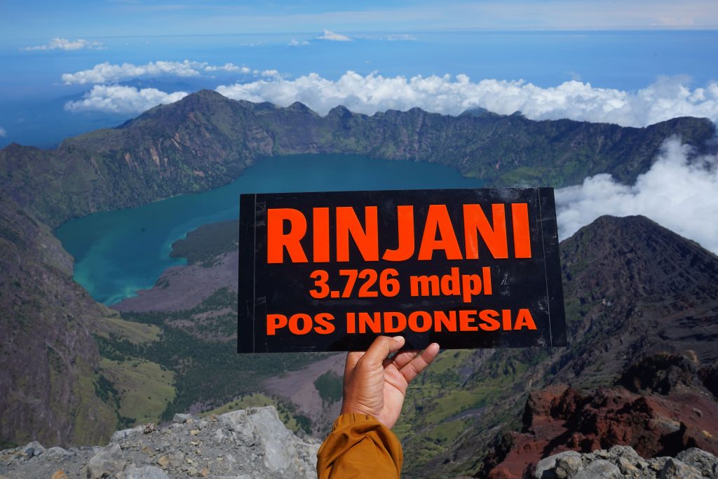
Mount Rinjani, located on the island of Lombok, West Nusa Tenggara, Indonesia, stands as the second-highest active volcano in the country. Rising 3,726 meters above sea level, it attracts trekkers for its dramatic scenery, spiritual meaning, and challenging routes. The volcano lies within the Mount Rinjani National Park, which spans 41,330 hectares and may expand to 76,000 hectares in the near future.
A Legacy of Fire and History
Mount Rinjani formed after the catastrophic eruption of Mount Samalas in 1257 AD. That explosion shook the world. It caused a global temperature drop, crop failures, and the collapse of the Pamatan Kingdom in Lombok. Today, its massive caldera holds Segara Anak Lake and the new volcanic cone of Mount Barujari.
The volcano stretches across East Lombok, Central Lombok, and North Lombok Regencies. Its long geological history and spectacular landscape make it both a natural wonder and a sacred site for local people.
The Remarkable Topography of Mount Rinjani
The summit of Mount Rinjani, at 3,726 meters, dominates northern Lombok’s skyline. On the western side, a vast caldera stretches 3.5 by 4.8 kilometers from east to west. Inside lies Segara Anak Lake, meaning Child of the Sea in the Sasak language. The lake covers 11 million square meters and plunges 230 meters deep. Its turquoise water resembles the sea, making it one of Indonesia’s most scenic crater lakes.
Streams flow from the lake, cascading through cliffs to form majestic waterfalls. These streams feed local rivers and provide fertile valleys below. The lake holds carp and tilapia, offering excellent fishing opportunities.The lake’s southern section is called Segara Endut.
Mount Barujari – The Child Volcano
On the eastern side of the caldera stands Mount Barujari, a smaller yet active volcanic cone. It rises between 2,296 and 2,376 meters above sea level and has a crater 170 by 200 meters wide. Locals often call it the “Child of Rinjani.”
Mount Barujari has erupted several times — in 1944, 1966, 1994, 2004, 2009, and 2015. The 2009 eruption triggered flash floods that claimed 31 lives when lava pushed against Segara Anak’s water. Its most recent eruptions occurred on October 25 and November 3, 2015, sending ash clouds visible as far as Bali.
Another smaller vent, Mount Rombongan, also erupted in the past, showing that Rinjani’s volcanic system remains active and evolving.
Geological Formation and Stratigraphy
Mount Rinjani stands on Neogene clastic sedimentary rocks such as limestone. In some areas, it rests on Oligo-Miocene volcanic deposits. Most of its Quaternary eruptions produced layers of pyroclastic material mixed with lava flows. Since 1847, records show at least seven eruptions, with intervals between one and thirty-seven years.
After the caldera formed, new eruptions created lava flows and explosive deposits. The dark basaltic lava looks foamy as it cools. Lava from Barujari and Rombongan is thicker and wetter than that of other volcanoes in Indonesia. Because most activity remains inside the caldera, pyroclastic surges rarely occur.
However, lava and lahar flows can travel toward Kokok Putih and Batusantek Rivers, particularly after heavy rain.
Structure and Tectonics
The east–west shape of Segara Anak Caldera likely formed due to fractures in the bedrock. Mount Rinjani lies on the Sunda Arc, a volcanic chain created by the subduction of the Indian Ocean Plate beneath the Eurasian Plate. This movement pushes north–south compression forces while stretching the crust east–west. As a result, Rinjani’s caldera fractures are thought to be tensional cracks, created by these opposing forces. The structure began forming during the early Quaternary period and continues to evolve today.
Trekking Mount Rinjani – A Journey of Challenge and Faith
Climbing Mount Rinjani offers both adventure and spiritual reflection. Every year, thousands of trekkers from around the world come to experience its rugged trails and sweeping views. The best time to hike is during the dry season (April–October). In July and August, the mountain gets especially busy. Around Indonesia’s Independence Day in mid-August, students and outdoor clubs climb Rinjani to celebrate at the summit and Segara Anak Lake. This event, known as “Tapak Rinjani,” is organized annually by local nature groups and the Rinjani National Park Authority.
Two official trekking routes lead to the top: the Senaru Route from the north and the Sembalun Route from the east. Each route offers unique scenery and challenges, but both lead to Segara Anak Lake, the heart of the mountain.
The Enchantment of Segara Anak Lake
Segara Anak Lake sits at 2,010 meters above sea level and covers around 1,100 hectares. It is about 230 meters deep and shaped like a crescent moon. The lake’s calm blue surface reflects the surrounding cliffs and volcanic cone, creating a breathtaking view for every visitor.
Around the lake, flat grassy plains provide perfect camping spots. Many visitors fish in the lake, relax in hot springs, or explore nearby caves. The sulfuric hot springs are believed to have healing and spiritual properties.
Close to the lake are several points of interest:
- Koko Puteq River Source, about 150 meters away
- Goa Susu (Milk Cave), a peaceful place for meditation
- Goa Manik and Goa Payung, which hold cultural and geological importance
Below the lake, the Aik Kalak Hot Springs are famous for testing sacred heirlooms such as daggers and swords. According to local beliefs, an item that remains firm when soaked is considered spiritually powerful, while one that becomes sticky is not.
A Symbol of Harmony and Life
Beyond its geological beauty, Mount Rinjani holds deep spiritual significance. For the people of Lombok, it represents balance between humans and nature. The Balinese Hindu community performs the Pekelan ceremony at Segara Anak to give thanks for prosperity and harmony.
Rinjani reminds us that destruction and creation exist together. Its eruptions renew the land, and its quiet moments offer peace. It stands as a living symbol of Indonesia’s natural and spiritual strength.